Our new research reveals that the areas most at risk are not necessarily the places with the most extreme weather, but those where hazards meet vulnerable communities.
Imagine a city where heavy rainfall brings traffic to a standstill and floods damage homes and infrastructure. Months later, the same region struggles with water shortages, putting pressure on households, farmers and local economies. These may seem like two separate problems, but should they be managed separately?
A new study of the Bengaluru Metropolitan Region (BMR) in India suggests that the answer is no. By examining flood and drought risks together, we have identified areas where environmental hazards and social vulnerability combine to create particularly high risks.
The findings highlight an important message for rapidly growing cities: understanding disaster risk means looking beyond the hazards themselves to the people, livelihoods and infrastructure exposed to them.
A rapidly growing region facing two extremes
Bengaluru, one of India’s largest and fastest-growing urban regions, has experienced enormous population growth and changes in land use over recent decades. Urban expansion has transformed the landscape, reducing natural and permeable surfaces and placing pressure on water systems.
These changes matter. When heavy rainfall falls on surfaces that cannot absorb water easily, runoff can increase and contribute to flooding. At the other end of the hydrological cycle, prolonged dry conditions can intensify water shortages, particularly where communities depend on groundwater or agriculture.
Floods and droughts are often addressed by different authorities, using separate plans and priorities. But this approach risks overlooking an important question: where do flood and drought risks overlap with communities that have limited capacity to cope?
Looking at risk from three perspectives
Rather than focusing only on where floods or droughts are likely to occur, we combined three dimensions of risk:
- Hazard: Where are floods and droughts likely to pose a threat?
- Exposure: Which people, infrastructure, agricultural areas and other assets are located in potentially affected areas?
- Vulnerability: How susceptible are those people and assets to harm, and how difficult might it be for them to cope?
We integrated environmental and socio-economic indicators into spatial risk maps at a fine administrative scale. We also used expert-informed weighting that incorporated both methodological expertise and knowledge of the local context.
This approach provides a more comprehensive picture than examining individual hazards in isolation. A location exposed to a hazard does not automatically experience the highest risk. The consequences also depend on what is exposed and how vulnerable it is.
What did we discover?
The analysis revealed several important patterns across the Bengaluru Metropolitan Region.
1. Drought is a major driver of combined risk
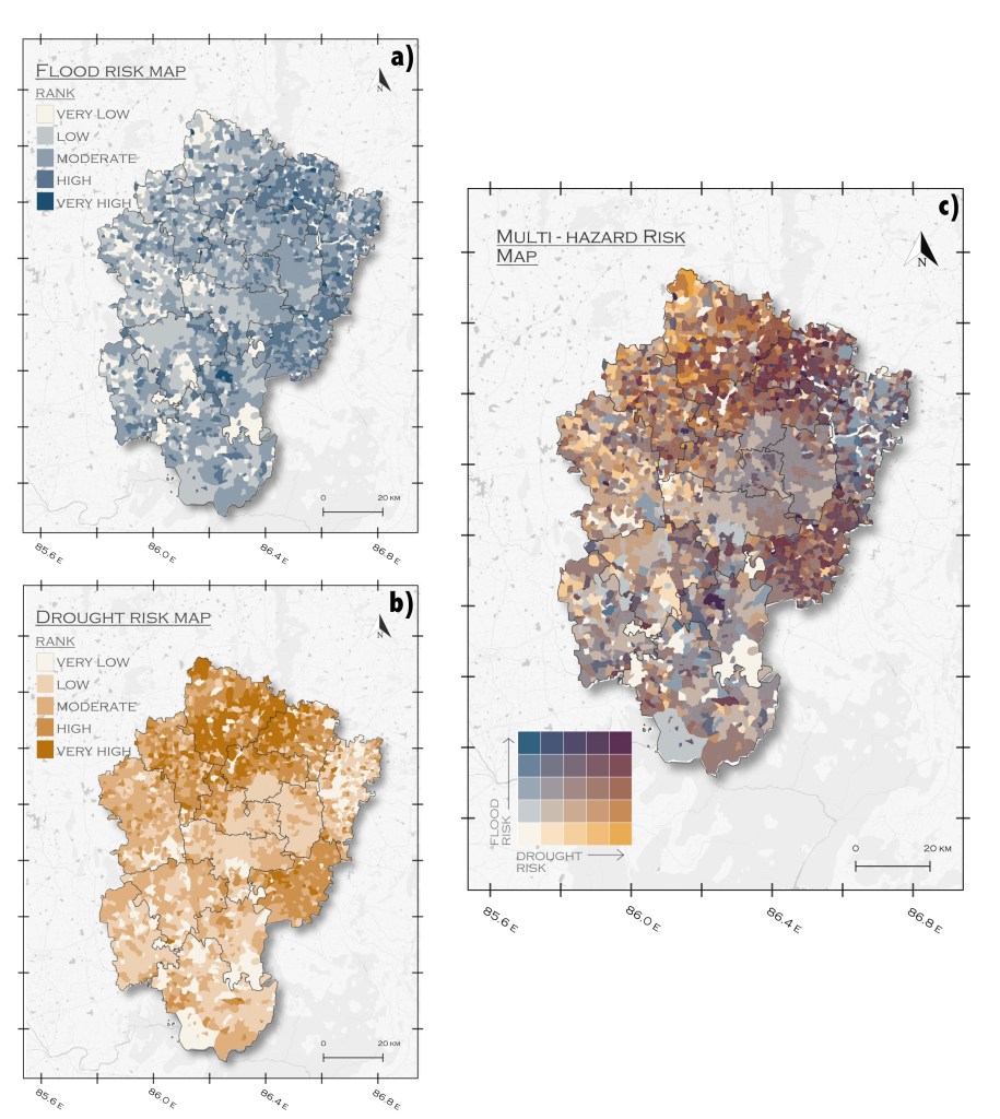
Although Bengaluru is widely associated with urban flooding, the study found that drought was the dominant contributor to the overall multi-hazard risk pattern.
Drought risk covered a broader area and coincided with high vulnerability, particularly in rural and peri-urban locations. These areas often depend heavily on groundwater, irrigation and agriculture, making water shortages especially challenging.
Flood risk, by comparison, was more spatially fragmented. Urban centres may have substantial exposure to flooding, but high exposure alone does not necessarily translate into the highest combined risk.
This finding demonstrates why a city’s disaster priorities cannot be determined simply by looking at the most visible or disruptive events.
2. Rural and peri-urban communities deserve greater attention
The study identified particularly concerning multi-hazard risk patterns in Bengaluru Rural district and surrounding peri-urban areas, including Doddaballapur.
These locations illustrate how environmental pressures and socio-economic conditions can reinforce one another. Where drought exposure coincides with high vulnerability, communities may have fewer options for managing water shortages and protecting their livelihoods.
Interestingly, Bengaluru Urban district showed lower vulnerability and correspondingly lower risk in the assessment, despite its high exposure to hazards.
This does not mean that the urban core is free from disaster risk. Rather, it shows that risk varies depending on the interaction between hazards, exposure and vulnerability.
3. Flood and drought vulnerability have different causes
Another important finding is that the factors making people vulnerable to floods are not necessarily the same as those making them vulnerable to droughts.
Flood vulnerability was associated with characteristics of the built environment and infrastructure. Drought vulnerability, in contrast, was more closely linked to groundwater scarcity, irrigation intensity and agricultural employment.
This distinction has practical implications. Improving drainage infrastructure may help reduce flood impacts, but it will not necessarily address the underlying causes of agricultural water insecurity.
Effective disaster planning therefore requires measures tailored to the particular hazard and the local conditions that influence its consequences.
From risk maps to better decisions
The value of this research extends beyond producing maps. The results can help planners and disaster management authorities identify where action may be most urgently needed and which interventions are likely to be most appropriate.
For example, locations with high exposure but comparatively lower vulnerability may benefit from measures that reduce the hazard or limit exposure. In areas where vulnerability is the main driver of risk, improving water access, strengthening livelihoods and increasing the capacity to cope may be equally important.
An integrated assessment can also provide a shared evidence base for organisations responsible for water management, urban planning, agriculture and disaster risk reduction. Instead of working with separate assessments and competing priorities, they can use a common picture of risk to support coordinated decisions.
This is particularly important in rapidly urbanising regions, where administrative responsibilities, infrastructure development and environmental pressures often extend beyond the boundaries of a single city.
Looking beyond individual disasters
Floods and droughts may look like opposite problems, but both can reveal weaknesses in how a region manages water, develops infrastructure and supports vulnerable communities.
The research from Bengaluru demonstrates why disaster risk reduction needs to move beyond isolated, hazard-specific approaches. By considering floods, droughts, exposure and vulnerability together, decision-makers can gain a clearer understanding of where risks concentrate and why.
Ultimately, the goal is not simply to map hazards. It is to use that information to help communities prepare for future extremes, protect livelihoods and build more resilient urban and rural regions.
Want to learn more? Read the full scientific article here: Link


Leave a Reply