What if we could know, months before harvest, that a crop is likely to produce less than expected?
For farmers and agricultural decision-makers, this information could be extremely valuable. Early knowledge of potential yield losses can support better planning, from adjusting farm management to preparing for reduced production.
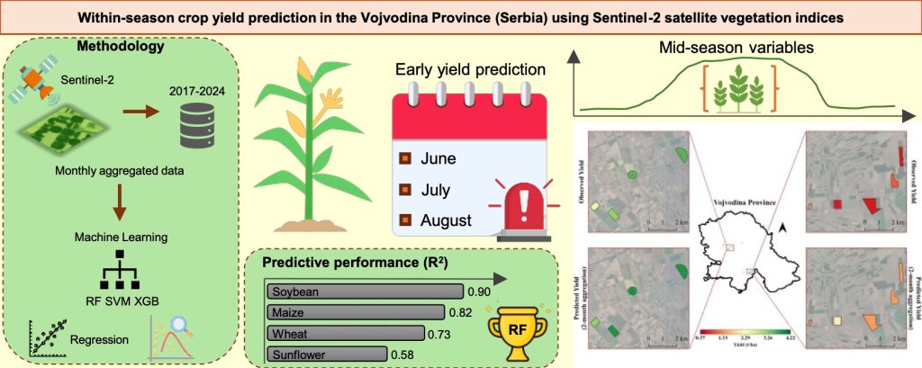
In our new study, we explored how Sentinel-2 satellite and machine learning can be used to predict crop yields (maize, wheat, soybean, and sunflower) during the growing season in Vojvodina, Serbia. This region is increasingly exposed to heat and drought. This makes timely information about crop conditions particularly important. Our study used field-level yield data across eight growing seasons (2017–2024), including several severe drought years.
Looking at crops from space
Sentinel-2 provides frequent, high-resolution observations of agricultural fields. Instead of relying only on what we can see with our eyes, satellites capture information about vegetation health, biomass, chlorophyll and plant moisture.
We calculated 14 vegetation indices from Sentinel-2 imagery and combined them with three machine-learning approaches: Random Forest, Support Vector Machine and XGBoost. The models were designed to predict crop yields using information available during the growing season—potentially at least two months before harvest.
The results were encouraging.
Soybean showed the strongest and most stable predictability, with Random Forest achieving an R² of 0.90 and a mean absolute error of only 0.26 tonnes per hectare using the three-month observation period. Maize also showed good performance, while wheat had moderate predictability. Sunflower was more challenging, although the prediction errors remained relatively low.
When does the satellite see the most important signal?
One of the most interesting findings was when the satellite information became most useful.
For maize, soybean and sunflower, vegetation indices from July were particularly important, while for wheat, May provided important information. These periods correspond to key stages of crop development, when plant biomass, chlorophyll and water availability strongly influence eventual yield.
The message is therefore not simply “more satellite data is better.” The timing of observations matters.
But there is still a challenge: extreme drought
The study also highlights an important limitation of machine-learning-based agricultural forecasting.
Although the models performed well overall, their performance declined when we tested them on individual years—particularly during unusual drought years such as 2022. When a drought year looks very different from the conditions represented in the training data, the model struggles to predict what it has never seen before.
This is particularly important in the context of climate change. The very events for which early-warning systems are most valuable—extreme droughts and unusual growing conditions—can also be the most difficult for models to predict.
From satellite imagery to an early-warning system
The ultimate goal is not simply to produce another machine-learning model. The real opportunity is to turn satellite observations into actionable information for farmers.
The study provides a pathway towards integrating crop-yield prediction models into the AgroSens platform, potentially enabling early detection of yield reductions and helping farmers prepare for losses.
There is still work to do: more observations from drought years are needed, particularly for crops such as sunflower, and the approach needs to be tested in other regions and agroecological conditions.
But the message is promising: satellites can give us a window into the future of our crops. By combining Earth observation with machine learning, we can move towards agricultural monitoring systems that detect potential yield losses early—giving farmers not just information about what is happening in their fields, but time to act.
You can read the full paper here: https://doi.org/10.1016/j.rsase.2026.102192




Leave a Reply