Indonesia is once again facing widespread forest and land fires, with major fire activity reported across parts of Sumatra and Kalimantan. Recent events are a reminder that forest and peatland fires remain a recurring challenge, particularly during prolonged dry conditions, like during current El Nino event in 2026.
To better understand where these fires occur, we have developed a fire hotspot map for Indonesia using MODIS fire detection data validated with fire reports from the National Disaster Management Agency (BNPB) for the period 2003–2025.
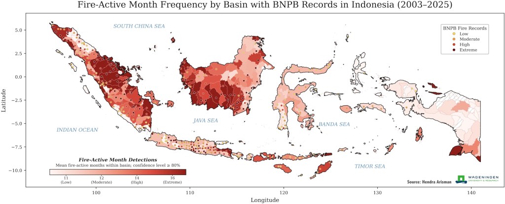
The concentration of hotspots is particularly evident across peatland areas in Sumatra and Kalimantan. This pattern highlights why peatlands should remain at the centre of Indonesia’s fire management strategy. Peat fires are particularly challenging because once peatlands become sufficiently dry, fires can spread underground and continue burning for long periods (see: Taufik et al., 2017).
From fire suppression to fire prevention
The map provides an important message: knowing where fires repeatedly occur can help us target prevention and preparedness efforts more effectively.
Fire management cannot rely only on responding once fires have started. In peatland areas, water management is equally important. Maintaining appropriate water levels, preventing excessive peat drainage, restoring degraded peatlands, and ensuring sufficient moisture during the dry season can reduce the conditions that allow peat fires to develop.
At the same time, effective fire management requires early detection, rapid response, community engagement, land-use management and law enforcement. This means that Indonesia needs to think about water management and fire management together.
A map is more than a picture
The hotspot map is not simply showing where fires have occurred. It can help us identify persistent fire-prone landscapes and ask a more important question:
How can we manage these landscapes before the next fire starts?
With increasingly variable rainfall and more frequent dry conditions, strengthening integrated peatland water management, fire prevention and early-warning systems will be essential for reducing the environmental, economic and health impacts of fires in Indonesia. The hotspots tell us where to look, and now we need to turn that information into action.
Ref: Taufik et al., 2017. https://www.nature.com/articles/nclimate3280




Leave a Reply