A recent article from NOS highlights a concerning development: the Netherlands is facing another dry spring, while soils have not yet recovered from the 2025 drought. This indicates that drought is not just a seasonal anomaly, but a clear example of how hydrological systems carry memory across years.
🌡️ A Compound Perspective on Drought
What makes this situation particularly important is not the dry spring alone, but the sequence of events. A severe drought in 2025 depleted soil moisture and groundwater storage while winter precipitation was insufficient to fully recharge the system. As a result, spring 2026 begins with a pre-existing moisture deficit, which is now intensifying.
From a compound events perspective, this case can be understood as a temporal compounding or a cascading event. The hydrological system has not fully recovered from the previous year, as reflected by low groundwater levels. In combination with below-average rainfall in spring, drought conditions are slowly developing. This situation may worsen during summer, when temperatures rise and less rainfall is expected. This raises an important question: do we know whether we will experience drought this summer?
🚨 Early Warning for the Netherlands
To answer this question, we are developing a drought early warning system for the Netherlands with a lead time of up to 6-month (LODESTAR project). In this system, we use drought indicators such as the Standardized Precipitation Index (SPI) and the Standardized Streamflow Index (SSI) to forecasts how precipitation deficits and streamflow develop. Every month, we rerun our models so that we can see how drought builds up and which regions are at risk first. These monthly updates support local case studies and better understand which societal sectors, such as agriculture, nature, and drinking water, are first affected when drought sets in.
At present, the indicators show a clear picture. River discharges remain around the long-term average, indicating only mild drought in major rivers (Fig. 1 left). At first glance, the situation appears manageable. However, beneath the surface signal, there are less reassuring indications: groundwater levels in the high sandy soils remain persistently low, and soil moisture deficits in parts of Germany have not yet fully recovered. Combined with a an increasing frequency of dry springs under a changing climate, thus suggests that we must continue to monitor the situation closely. Forecast for June also do not show strong recovery signals. Mild drought conditions in major rivers are expected to persist into summer (Fig. 1 right). This means that we are not yet out of the risk zone This is precisely where an effective early warning system becomes essential.
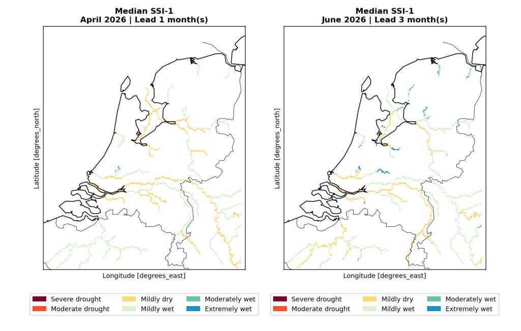
Figure 1. Streamflow drought forecasts initiated on 10th April 2026 to forecast drought in April (lead time 1 month) and June (lead time 3 months).
✍️ Takeaway
The current dry spring in the Netherlands is not just a weather anomaly, but a system response shaped by past extremes. Rather than an isolated event, it reflects the cumulative effects of consecutive drought conditions. Understanding and managing such events requires a shift from simple monitoring toward early warning anticipation, where the focus is not only on current conditions, but also on future development and timely decision-making.
Contributors: Inge de Graaf and Rhoda Odongo.


Leave a comment